Showing posts with label mountains. Show all posts

6/05/2015

They say it's been there all along

I have been working in Enumclaw, Washington for a week now and this is my first glimpse of Mount Rainier. 

If I move my head just right, squint and look through the trees, I have my own view of this mountain from my office. 
Western Washington is well renowned for being wet for which I will attest.

10/27/2013

Another run at Yosemite

Instead of going back into the ever popular Yosemite Valley, I followed California Highway 120 east.   After driving through quaint little mountain communities like Groveland and Big Oak Flat, I approached the beginnings of the signs of the very large rim fire in September.

Pulling off to take a picture in one of the side road pull-outs, a U S Forest Service guy quickly pulls up in an official truck and tells me I can't even stop there to take a picture.

"I can't even take a picture??", I asked.

"No, you have to go another quarter mile to a designated area."

I didn't want to argue with him.  How long have foresters been armed with assault weapons?


That was pretty much the way it was all along the next few miles until I got officially into Yosemite National Park.


I had never been on Hwy 120 east, traveling north of the famed valley.  Admiring every pull-out, I often walked down little trails when I saw other cars parked.  Really, I wanted to see waterfalls but this time of the year, I was lucky to see water at all.


At one point I took a little hike to the stream bed for the source of the iconic Yosemite Falls. Yep, it was dry as a bone and hard to imagine it flowing in the spring.


Again, stopping often, I was always amazed at how a seed from a tree could find it's way into a crack in all that granite and make itself a home.


Passing by the eastern side of the Yosemite Valley, I saw on one of the information stands that there was a lake a couple of miles on east.


Tenaya Lake was a pretty sight coming down from the peak at Olmsted Point.


I kept inching on and found myself in the Tuolumne Meadows before figuring out it might be time to turn around   This little part of this stream was just full of little 7- 8 inch trout.  Within weeks, this place will be 6 feet in snow.


On my way back, there was a couple of vehicles parked on one of the wide spots,  so I slowed down and pulled over to see what the attraction might be.

Up on the side of the huge rock, I thought I saw a movement.  Taking out my zoom lens, I focused in on what turned out to be one adult male and two smaller females, one of which (if not both) were merely children.  Thinking to myself, this is insane, I watched quite a while.  After all, I was 20 years old before I knew there was anything taller than the Louisiana State Capitol building in Baton Rouge.

As a matter of perspective, the first shot is of the rock itself.  The people are barely visible but are in the exact center of the photo.


As I watched, I realized they were about to rappel down.


The male went first, then the two girls after him.  Judging from the size of the helmet on one, this has to be a kid in the 8 or 9 year old range.  Not sure if you can zoom in or not. Just click on the photo and it should enlarge.


Watching two kids do this made me think that hitting a ton on a motorcycle or going into a cave underwater with a shark was very mild in comparison.


Apparently it wasn't that big of a deal to some because another truck pulled up, the guy and girl got out and looked for a moment then began pulling out their own ropes and equipment.  No thanks, I'll stick to level ground, thank you.

On stopping at the gates at Yosemite, I saw a sign telling me that everything but the actual valley parks would be closing November 1, so I'm glad I got a chance to visit that part of Yosemite.

Determined to find some evidence of fall colors, Yosemite left me with this parting shot.


9/28/2013

Another shot at Yosemite

After a week's vacation, once again, I'm back in Modesto.

Saturday morning, I began to figure out what I could do to amuse myself.  I eliminated San Francisco because, there's just too many people, traffic and ...just too many people.  So, I thought I'd take another shot at Yosemite National Park.


The ride down and over from Modesto was pretty nice, riding through the rolling hills through very little traffic.  Arriving there, I once again presented my (I hate to admit this) Senior National Parks pass to get in free.  A couple of miles on the road winding around boulders as big as houses, I found myself stopping several times just to soak it all in.


I climbed down the the very low flowing river, found a couple of ducks that had no more fear of humans than the deer I  had seen a few weeks ago when Darlene came up to visit.


Even squirrels and chipmunks were sometimes within arm's reach.


The road into Yosemite Valley is not a through road.  There are the iconic monuments such as El Capitan, Half Dome, Bridal Veil Falls, Mirror Lake and Yosemite falls, most of which can actually be observed from the comforts of your car if you're so inclined but you really can't appreciate it until you get out and walk.


The last time we were in Yosemite, the falls were completely dry but today, Bridal Veil had began to spray a little water over the top but not the signature Yosemite Falls.


I had hoped to see some fall flowers and colors other than brown grass but there just wasn't any flowers left.  I did find some tiny purple flowers near the edge of the road.  They were the last hold outs of the year.  Bear in mind, this is an extreme closeup shot and they are not larger than a half inch in diameter.  So that tiny bug in the center ( if you know how to zoom in on it - click the photo, hold down the ctrl key and scroll the wheel of your mouse) is very, very small.


This time of year, the crowds and traffic are greatly diminished but there were still plenty of cars, motorcycles, bicycles and buses.


Several times, I had passed a group of people with telescopes on tripods at the base of El Capitan.  A poster on the tailgate of a van encourage passers to "Ask A Climber".  OK, I believe I will.


I got out and walked over to a group of other curiosity seekers and eventually began to talk to a young woman who seemed very knowledgeable about climbers and what was actually going on.  It seemed her husband and a climbing partner were up on the side of that piece of solid granite, climbing to the top.  I've found amusement in a lot of dangerous things but I figure I have a lot more things to do before I run out of other things to do closer to the ground.  I believe that has to be worse than sky diving.  Again, if you can zoom in, there are 3 climbers in the very middle of this photo.


The lady told me that the trip up the side of that mountain would take 2 ½ days to reach the top and another half a day to walk down the trail behind it. She herself, was a climber.


It was virtually impossible to make them out without the benefit of a telescope or in my case, a 200 mm zoom lens on my camera.  Even that was really insufficient for a good look.

I watched for an hour or so, soaking in a lot of information I probably didn't really need to know.  She told me those big bags they were pulling up with them, was supplies including bedding (I don't know how they could sleep), food, climbing ropes and (you won't believe this) an orange colored bag to carry body waste in.  The rules are, you bring everything back with you, including that.  They also had a few beers that they would pop a top on to celebrate when they reached the top.

Of the climbers, there were four distinct groups in various places and heights on El Capitan.  One group of three were all females.


Anyway, it was a nice trip and really hated to head back into the setting sun.


6/02/2012

As the days get longer...

..there is a lot more daylight now, so after work Friday, I drove up to Sunspot, NM.  Sunspot sits on the plateau above Alamogordo and is the home of the National Solar Observatory.

(clicking on the photo will enlarge them)

My intent was to get there, find a spot overlooking the White Sands National Monument and photograph a sunset but due to recent fires in the Gila National Forest and lots of clouds from a light cool front, visibility was limited.  I had also hoped to do some timed photos that would create circular star trails, but that's for another time.


Even though I was a bit disappointed that the clouds and weather were not cooperating, wildlife was everywhere.  This is a protected area so the animals aren't all that spooky if you don't come to a complete stop and/or get out of the car.  Forgive me if I have this wrong but I'm thinking these are Mule Deer.  I know I've never seen one in Louisiana and never claimed to be an expert.                    


(Update!  A knowledgeable friend tells me, he's pretty sure they are Elk.)


A young doe.


On the way back home (the hotel) I pulled off onto a less than wonderful road to check out cactus flowers under the approaching full moon.


And from the opposite direction, a sunset.


Probably, it wasn't a great idea getting too far off the pavement in a VW Passat rental car (National Car frowns on those activities) but it's not because I didn't want too.

10/07/2007

North Georgia


September 14: With less than 24 hours since arriving in Baton Rouge from Virginia, I was already booking a flight to Burlington, Iowa. Thinking it impossible to be more remote than that, within 3 hours, the phone rang and my trip to Burlington was canceled and I on the cell phone in traffic booking a trip to Blairsville, GA. Not knowing for sure where that place was, I relied on the travel agent to choose the best airport. She tells me, "Knoxville". "Tennessee?", I asked. "Yep, your other choices are Asheville, Chattanooga or Atlanta". "Well", says I, "that's three states and a lot of space between those towns, are you sure?". Long story short, I'm on a flight early Thursday morning, flying over the tropical storm that had just passed through Louisiana and landing right back in the middle of it. Relying on my trusty (?) Garmin GPS, I took it's advice and went blazing down the road and within 30 minutes I'm on some little road in a drizzling rain questioning the wisdom of Mr. Garmin's invention. When I tell you that road was crooked, that is an understatement. At one point, I kid you not, I looked through the trees to my right and saw a car put on it's brake lights and 15 seconds later, I met that same car in the next curve. My trip to Blairsville lasted three hours through these curves and rain and had me muttering near profanities at the thought of my travel agent and the folks at Garmin Industries.

Blairsville is a Mayberyesque town of around 700 full time citizens with an old courthouse occupying the pivot point of a roundabout. The office where I met up with Wally, the other rep, sits on the north side of it. Unfortunately, it was nearly closing time by the time I arrived so Wally and I went out scouting for a place to stay. We chose Holiday Inn Express after a quick look at couple of other motels, thinking it was the safest bet, not knowing anything about the place.

September 26: After spending the past two days in St Louis, I flew back to Georgia. Thinking it might be best to fly into Atlanta, I flew in on American this time, giving my usual rant about Delta a rest. Feeling fortunate that we arrived on time, I retrieved my bags and tried to find the rental car shuttle bus. Atlanta's signage is less than wonderful so I found myself pulling two large bags to and fro outside the terminal building. After asking and receiving bad advice from two sources, I eventually was aboard the shuttle.

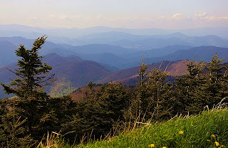
Instead of driving the fastest way, Saturday morning I checked out of my Patel and took Hwy 19 north. It soon became much more scenic than Hotlanta when I began to get into the north Georgia mountains. Arriving in Dahlonegah, I checked out a couple of motels and eventually unloaded at the Super 8. Believe it or not, it had more going on for it than the Holiday Inn Express and a lot cheaper to boot.

Dahlonegah, was hosting a couple of bike rides, one 50 mile ride and a hundred miler. There was more spandex covered butts there than at the flea market in Gonzales, LA. This small college town has a pretty neat historic downtown with satellites of shops and cafes all around the old courthouse. While the main attraction was supposed to be bicycles, the tight turned roads were constantly yielding to various arays of Porches, Beemers, vintage roadsters and everything imaginable in motorcycles.

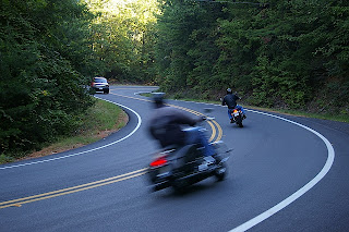
October 6 and 7: Wow! Were the natives excited about the Sorghum Festival! Complete with a canon shot to start the parade Saturday morning, Blairsville denizens turned out on the courthouse square to take in the sights of all 5 fire trucks, Boy Scouts, people on stilts, Shriners, the high school marching band and every restored Camaro or Mustang still running. True enough, in conventional terms of traveling, there isn't a lot going on for Blairsville but somewhere deep down in your soul you'll find a lot and your heart will be better for the experience.

The last 3 weeks, I decided to stay at the Seasons Inn right on the square. It's an older inn that had been bought and run by a young couple. Furnishing were spartan but nevertheless, it was fitting for my stay in Mayberry......er...Blairsville.